Will AI replace cartographers and photogrammetrists?
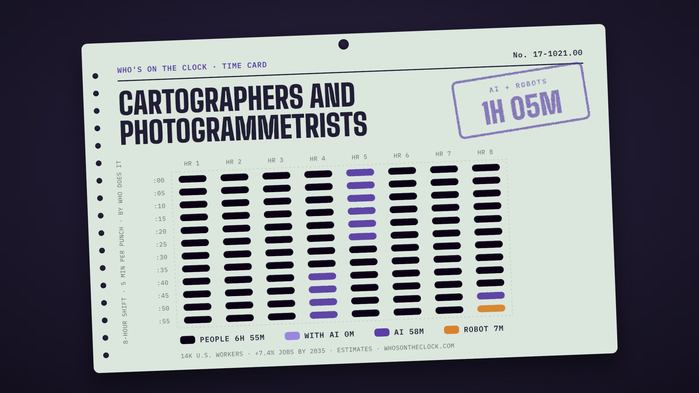
Unlikely, though parts of the work are changing. About 1h 5m of an 8-hour shift goes to tasks touched by AI working on its own. The breakdown: 58m that AI mostly does alone, 7m that robots have done in real workplaces. The other 6h 55m (87%) stays with people. Separately, BLS expects about 7.4% more of these jobs by 2035 (all jobs: +3.5%).
⤢ Full sizeEach mark is 5 minutes of a typical shift for cartographers and photogrammetrists, colored by who does that task today. Estimates from O*NET tasks and Anthropic Economic Index data. How it's made
Research, study, and prepare maps and other spatial data in digital or graphic form for one or more purposes, such as legal, social, political, educational, and design purposes. May work with Geographic Information Systems (GIS). May design and evaluate algorithms, data structures, and user interfaces for GIS and mapping systems. May collect, analyze, and interpret geographic information provided by geodetic surveys, aerial photographs, and satellite data.
Time card
Untick tasks you don't do, or set your own times.
Mine
Task, by time spent
Human
With AI
AI
Robot
Prepare and alter trace maps, charts, tables, detailed drawings, and three-dimensional optical models of terrain using stereoscopic plotting and computer graphics equipment.58m a shift · No AI or robot evidence found
Examine and analyze data from ground surveys, reports, aerial photographs, and satellite images to prepare topographic maps, aerial-photograph mosaics, and related charts.58m a shift · No AI or robot evidence found
Compile data required for map preparation, including aerial photographs, survey notes, records, reports, and original maps.52m a shift · No AI or robot evidence found
Revise existing maps and charts, making all necessary corrections and adjustments.52m a shift · No AI or robot evidence found
Build and update digital databases.52m a shift · Observed in AI useTypical AI request: about 1h 5m alone, 7m with AI
Inspect final compositions to ensure completeness and accuracy.39m a shift · No AI or robot evidence found
Determine map content and layout, as well as production specifications such as scale, size, projection, and colors, and direct production to ensure that specifications are followed.39m a shift · No AI or robot evidence found
Delineate aerial photographic detail, such as control points, hydrography, topography, and cultural features, using precision stereoplotting apparatus or drafting instruments.32m a shift · No AI or robot evidence found
Identify, scale, and orient geodetic points, elevations, and other planimetric or topographic features, applying standard mathematical formulas.32m a shift · No AI or robot evidence found
Collect information about specific features of the Earth, using aerial photography and other digital remote sensing techniques.26m a shift · No AI or robot evidence found
Study legal records to establish boundaries of local, national, and international properties.13m a shift · No AI or robot evidence found
Select aerial photographic and remote sensing techniques and plotting equipment needed to meet required standards of accuracy.13m a shift · No AI or robot evidence found
Determine guidelines that specify which source material is acceptable for use.6m a shift · Observed in AI useTypical AI request: about 5h 9m alone, 55m with AI
No company news tracked for this job yet. New stories are added as they happen.
Ask the clock
Will AI replace cartographers and photogrammetrists?
Unlikely, though parts of the work are changing. About 1h 5m of an 8-hour shift goes to tasks touched by AI working on its own. The breakdown: 58m that AI mostly does alone, 7m that robots have done in real workplaces. The other 6h 55m (87%) stays with people. Separately, BLS expects about 7.4% more of these jobs by 2035 (all jobs: +3.5%).
What can AI already do for cartographers and photogrammetrists?
AI shows up regularly in 2 of 14 tasks, about 58m of a typical shift. The biggest ones:
Build and update digital databases. (52m a shift, AI mostly does it alone)
Determine guidelines that specify which source material is acceptable for use. (6m a shift, AI mostly does it alone)
Where do robots fit in?
For some tasks, yes. Robots have done 1 of this job's tasks in workplaces like this one, about 7m of a typical shift.
Travel over photographed areas to observe, identify, record, and verify all relevant features. (6m a shift; e.g. Waymo Driver (autonomous vehicle fleet with automated map-change detection), in use)
What still needs a person?
6h 55m of a typical shift, or 87%, goes to tasks with no AI or robot evidence yet. No AI usage or robot deployment has shown up for these so far. The biggest:
Prepare and alter trace maps, charts, tables, detailed drawings, and three-dimensional optical models of terrain using stereoscopic plotting and computer graphics equipment. (58m a shift)
Examine and analyze data from ground surveys, reports, aerial photographs, and satellite images to prepare topographic maps, aerial-photograph mosaics, and related charts. (58m a shift)
Compile data required for map preparation, including aerial photographs, survey notes, records, reports, and original maps. (52m a shift)
Revise existing maps and charts, making all necessary corrections and adjustments. (52m a shift)
Inspect final compositions to ensure completeness and accuracy. (39m a shift)
Why is that work hard to automate?
Much of it comes down to where and how the work happens. In-person, hands-on and high-stakes work is where AI and robots have made the least headway so far. In the official O*NET survey of people in this job:
81% use their hands on tools, objects or controls more than half the time
71% talk face to face with others every day
69% say dealing with the public is very or extremely important
How much time does AI save on these tasks?
For the 2 tasks in this job where AI shows up and timing data exists, a typical request takes about 3h 7m for a person alone and about 31m with AI. These are Claude's own estimates from real conversations in April and May 2026 (Anthropic Economic Index). They describe single requests, not whole workdays, and time saved on a task doesn't mean jobs are cut. The biggest gaps:
Determine guidelines that specify which source material is acceptable for use (about 5h 9m alone, 55m with AI)
Build and update digital databases (about 1h 5m alone, 7m with AI)
Are employers still hiring cartographers and photogrammetrists?
On Indeed, job postings in the Architecture sector are at 92% of their February 2020 level (all U.S. postings: 104%), up 5.5% from a year earlier, as of Oct 9, 2026. BLS separately expects about 900 openings a year in this job through 2035. Across all U.S. postings, 7.3% now mention AI skills. Sector postings cover more than this one job and move for many reasons besides AI.
How much do cartographers and photogrammetrists make?
The median pay is about $81,390 a year ($39.13 an hour), 60% above the median for all U.S. jobs ($50,980). Most people in this job earn between $53,740 and $126,950 a year; that range covers the middle 80%. Pay figures are from BLS, May 2025, and vary a lot by state and employer. Pick a state to compare:
Is this job growing or shrinking?
BLS projects growth of 7.4% from 2025 to 2035, compared with 3.5% growth for all jobs. That's about 16,000 jobs in 2035. It expects about 900 openings a year, mostly from people retiring or changing careers. These projections don't single out AI as a cause.
How many cartographers and photogrammetrists are there in the U.S.?
About 14,000 people in the U.S., roughly 0.01% of all workers (BLS, May 2025). That makes it the 603rd largest of the 796 jobs on this site. BLS expects about 16,000 in 2035.
What training do cartographers and photogrammetrists need?
The most common requirement is a post-secondary certificate: about 36% of people in the job said so in the official O*NET survey. O*NET rates the job at level 4 of 5 for preparation, which usually means: bachelor's degree. Requirements vary by state and employer, especially for licensed work.
What should I learn to stay ahead of AI?
These come from the job's official skill ratings and from the tasks that AI and robots touch least today. Building them keeps you strong in the parts of the work that still need a person:
Skills that matter more here than in most jobs: Reading Comprehension, Writing, Active Learning, Critical Thinking
Get strong at the parts of the job that stay with people (listed above), which take 6h 55m of a typical shift
Learn to use AI well on the tasks where it already shows up in this job (listed above)
What new tasks are cartographers and photogrammetrists taking on?
Yes. Occupational experts recently added these to the official task list, a sign of how the work itself is shifting. New tasks aren't rated for AI or robots yet:
Estimate resources, such as production hours, required for projects.
Use drone technology to capture high-resolution images and data for map creation and updating.
What other jobs could cartographers and photogrammetrists move into?
These use similar skills, with less of a typical shift touched by AI or robots. Matches come from 109 official ratings of skills, knowledge and work activities, and each needs the same or less preparation unless the official list relates the jobs directly:
Geodetic Surveyors (0m touched, $75k median pay)
Surveyors (17m touched, $75k median pay)
How solid are these numbers?
Each task carries its own evidence label. For this job: 2 observed in real AI use, 1 with robots in real deployments, 11 with no AI or robot evidence found. The minutes per task are estimates, not measured hours, and "no evidence" doesn't prove a task is safe.
Tools in demand
ESRI ArcGIS software
Adobe Acrobat
Adobe Creative Cloud software
Adobe Illustrator
Adobe InDesign
Adobe Photoshop
Autodesk AutoCAD
Bentley MicroStation
Also called
Aerial Photogrammetrist, Cadastral Mapper, Cartographer, Cartographic Designer, Cartographic Drafter, Cartography Technician, Data Mapper, Digital Cartographer, Field Map Editor, Geospatial Specialist, Imagery Analyst, LIDAR Technician (Light Detection and Ranging Technician), Map Editor, Map Maker