Will AI replace remote sensing technicians?

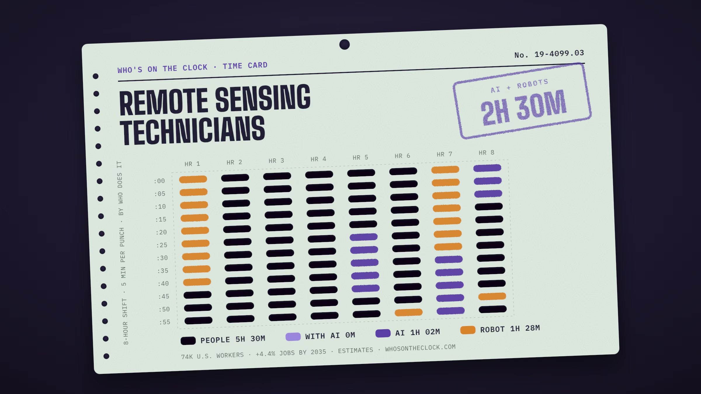
The biggest change here is physical: systems like Percepto Sparrow / Air Max with Percepto AIM have done tasks such as “Collect geospatial data” in real workplaces, about 1h 28m of a typical shift. Most of the rest, 5h 30m, has no AI or robot evidence. BLS expects about 4.4% more of these jobs by 2035.

Time card for remote sensing technicians showing a typical 8-hour shift: 5h 30m done by people, 1h 2m by AI, 1h 28m by robots.
Each mark is 5 minutes of a typical shift for remote sensing technicians, colored by who does that task today. Estimates from O*NET tasks and Anthropic Economic Index data. How it's made

Home / Science / Remote Sensing Technicians

Apply remote sensing technologies to assist scientists in areas such as natural resources, urban planning, or homeland security. May prepare flight plans or sensor configurations for flight trips.

Time card

Untick tasks you don't do, or set your own times.
MineTask, by time spentHumanWith AIAIRobot
Collect geospatial data, using technologies such as aerial photography, light and radio wave detection systems, digital satellites, or thermal energy systems.44m a shift · Robots deployed · e.g. Percepto Sparrow / Air Max with Percepto AIM
Why this label?Marked Robot because Percepto Sparrow / Air Max with Percepto AIM (in real use) has done this task in a real workplace. It shows a robot can do it somewhere, not that most remote sensing technicians work alongside one. How labels work
Verify integrity and accuracy of data contained in remote sensing image analysis systems.37m a shift · No AI or robot evidence found
Why this label?No AI use or robot deployment showed up for this task in our data. That isn't proof it's safe; it may just be rare in the data. How labels work
Integrate remotely sensed data with other geospatial data.37m a shift · No AI or robot evidence found
Why this label?No AI use or robot deployment showed up for this task in our data. That isn't proof it's safe; it may just be rare in the data. How labels work
Adjust remotely sensed images for optimum presentation by using software to select image displays, define image set categories, or choose processing routines.37m a shift · No AI or robot evidence found
Why this label?No AI use or robot deployment showed up for this task in our data. That isn't proof it's safe; it may just be rare in the data. How labels work
Consult with remote sensing scientists, surveyors, cartographers, or engineers to determine project needs.31m a shift · No AI or robot evidence found
Why this label?No AI use or robot deployment showed up for this task in our data. That isn't proof it's safe; it may just be rare in the data. How labels work
Manipulate raw data to enhance interpretation, either on the ground or during remote sensing flights.31m a shift · No AI or robot evidence found
Why this label?No AI use or robot deployment showed up for this task in our data. That isn't proof it's safe; it may just be rare in the data. How labels work
Correct raw data for errors due to factors such as skew or atmospheric variation.31m a shift · No AI or robot evidence found
Why this label?No AI use or robot deployment showed up for this task in our data. That isn't proof it's safe; it may just be rare in the data. How labels work
Participate in the planning or development of mapping projects.25m a shift · No AI or robot evidence found
Why this label?No AI use or robot deployment showed up for this task in our data. That isn't proof it's safe; it may just be rare in the data. How labels work
Prepare documentation or presentations, including charts, photos, or graphs.25m a shift · Observed in AI useTypical AI request: about 10h 43m alone, 34m with AI
Why this label?Marked AI because this task shows up regularly in real AI conversations (Anthropic Economic Index, 2025 usage), and in most of them AI does the task on its own rather than helping a person. Many workplaces may not use AI for it at all. How labels work
Develop or maintain geospatial information databases.25m a shift · No AI or robot evidence found
Why this label?No AI use or robot deployment showed up for this task in our data. That isn't proof it's safe; it may just be rare in the data. How labels work
Merge scanned images or build photo mosaics of large areas, using image processing software.19m a shift · No AI or robot evidence found
Why this label?No AI use or robot deployment showed up for this task in our data. That isn't proof it's safe; it may just be rare in the data. How labels work
Calibrate data collection equipment.19m a shift · Robots only in factory cells
Why this label?Robots have done this only in factory setups built around the machine, so it stays Human for remote sensing technicians. How labels work
Monitor raw data quality during collection, and make equipment corrections as necessary.19m a shift · Robots deployed · e.g. Percepto Air / Percepto Base / AIM
Why this label?Marked Robot because Percepto Air / Percepto Base / AIM (in real use) has done this task in a real workplace. It shows a robot can do it somewhere, not that most remote sensing technicians work alongside one. How labels work
Collect verification data on the ground, using equipment such as global positioning receivers, digital cameras, or notebook computers.19m a shift · Robots deployed · e.g. Waymo Driver robotaxi fleet
Why this label?Marked Robot because Waymo Driver robotaxi fleet (in real use) has done this task in a real workplace. It shows a robot can do it somewhere, not that most remote sensing technicians work alongside one. How labels work
Document methods used and write technical reports containing information collected.19m a shift · Observed in AI useTypical AI request: about 12h 10m alone, 41m with AI
Why this label?Marked AI because this task shows up regularly in real AI conversations (Anthropic Economic Index, 2025 usage), and in most of them AI does the task on its own rather than helping a person. Many workplaces may not use AI for it at all. How labels work
Develop specialized computer software routines to customize and integrate image analysis.19m a shift · Observed in AI useTypical AI request: about 9h 12m alone, 1h 10m with AI
Why this label?Marked AI because this task shows up regularly in real AI conversations (Anthropic Economic Index, 2025 usage), and in most of them AI does the task on its own rather than helping a person. Many workplaces may not use AI for it at all. How labels work
Maintain records of survey data.12m a shift · No AI or robot evidence found
Why this label?No AI use or robot deployment showed up for this task in our data. That isn't proof it's safe; it may just be rare in the data. How labels work
Evaluate remote sensing project requirements to determine the types of equipment or computer software necessary to meet project requirements, such as specific image types or output resolutions.12m a shift · No AI or robot evidence found
Why this label?No AI use or robot deployment showed up for this task in our data. That isn't proof it's safe; it may just be rare in the data. How labels work
Collaborate with agricultural workers to apply remote sensing information to efforts to reduce negative environmental impacts of farming practices.6m a shift · No AI or robot evidence found
Why this label?No AI use or robot deployment showed up for this task in our data. That isn't proof it's safe; it may just be rare in the data. How labels work
Collect remote sensing data for forest or carbon tracking activities involved in assessing the impact of environmental change.6m a shift · Robots deployed · e.g. USGS multirotor UAS lidar/imagery collection (National Uncrewed Systems Office)
Why this label?Marked Robot because USGS multirotor UAS lidar/imagery collection (National Uncrewed Systems Office) (in real use) has done this task in a real workplace. It shows a robot can do it somewhere, not that most remote sensing technicians work alongside one. How labels work
Provide remote sensing data for use in addressing environmental issues, such as surface water modeling or dust cloud detection.6m a shift · No AI or robot evidence found
Why this label?No AI use or robot deployment showed up for this task in our data. That isn't proof it's safe; it may just be rare in the data. How labels work

Clock history

  1. 2h 30m touchedFirst published: O*NET 30.1, Anthropic Economic Index (2025 usage and September 2026 robot study), BLS May 2025

When new data changes this clock, the date, the new numbers and the reason are logged here. Company news alone never moves the clock.

On the floor

No company news tracked for this job yet. New stories are added as they happen.

Ask the clock

Will AI replace remote sensing technicians?

Some tasks are already being done by AI or machines; the rest still needs a person. About 2h 30m of a typical shift is made up of tasks that AI or robots have done on their own in real use somewhere. That doesn't mean those hours are automated in a typical workplace. The breakdown: 1h 2m that AI mostly does alone, 1h 28m that robots have done in real workplaces. The other 5h 30m (69%) stays with people. Separately, BLS expects about 4.4% more of these jobs by 2035 (all jobs: +3.5%).

What can AI already do for remote sensing technicians?

AI shows up regularly in 3 of 21 tasks, about 1h 2m of a typical shift. The biggest ones:

  • Prepare documentation or presentations, including charts, photos, or graphs. (25m a shift, AI mostly does it alone)
  • Document methods used and write technical reports containing information collected. (19m a shift, AI mostly does it alone)
  • Develop specialized computer software routines to customize and integrate image analysis. (19m a shift, AI mostly does it alone)
Where do robots fit in?

For some tasks, yes. Robots have done 4 of this job's tasks in workplaces like this one, about 1h 28m of a typical shift. 1 more task has only been done in factory setups built around the machine, so it stays with people here.

  • Collect geospatial data, using technologies such as aerial photography, light and radio wave detection systems, digital satellites, or thermal energy systems. (44m a shift; e.g. Percepto Sparrow / Air Max with Percepto AIM, in use)
  • Monitor raw data quality during collection, and make equipment corrections as necessary. (19m a shift; e.g. Percepto Air / Percepto Base / AIM, in use)
  • Collect verification data on the ground, using equipment such as global positioning receivers, digital cameras, or notebook computers. (19m a shift; e.g. Waymo Driver robotaxi fleet, in use)
  • Collect remote sensing data for forest or carbon tracking activities involved in assessing the impact of environmental change. (6m a shift; e.g. USGS multirotor UAS lidar/imagery collection (National Uncrewed Systems Office), in use)
What still needs a person?

5h 30m of a typical shift, or 69%, goes to tasks with no AI or robot evidence yet. No AI usage or robot deployment has shown up for these so far. The biggest:

  • Verify integrity and accuracy of data contained in remote sensing image analysis systems. (37m a shift)
  • Integrate remotely sensed data with other geospatial data. (37m a shift)
  • Adjust remotely sensed images for optimum presentation by using software to select image displays, define image set categories, or choose processing routines. (37m a shift)
  • Consult with remote sensing scientists, surveyors, cartographers, or engineers to determine project needs. (31m a shift)
  • Manipulate raw data to enhance interpretation, either on the ground or during remote sensing flights. (31m a shift)
Why is that work hard to automate?

Much of it comes down to where and how the work happens. In-person, hands-on and high-stakes work is where AI and robots have made the least headway so far. In the official O*NET survey of people in this job:

  • 63% talk face to face with others every day
  • 56% use their hands on tools, objects or controls more than half the time
How much time does AI save on these tasks?

For the 3 tasks in this job where AI shows up and timing data exists, a typical request takes about 10h 43m for a person alone and about 41m with AI. These are Claude's own estimates from real conversations in April and May 2026 (Anthropic Economic Index). They describe single requests, not whole workdays, and time saved on a task doesn't mean jobs are cut. The biggest gaps:

  • Document methods used and write technical reports containing information collected (about 12h 10m alone, 41m with AI)
  • Prepare documentation or presentations, including charts, photos, or graphs (about 10h 43m alone, 34m with AI)
  • Develop specialized computer software routines to customize and integrate image analysis (about 9h 12m alone, 1h 10m with AI)
Are employers still hiring remote sensing technicians?

On Indeed, job postings in the Scientific Research & Development sector are at 84% of their February 2020 level (all U.S. postings: 104%), up 19.9% from a year earlier, as of Oct 9, 2026. BLS separately expects about 11,000 openings a year in this job through 2035. Across all U.S. postings, 7.3% now mention AI skills. Sector postings cover more than this one job and move for many reasons besides AI.

How much do remote sensing technicians make?

The median pay is about $62,280 a year ($29.94 an hour), 22% above the median for all U.S. jobs ($50,980). Most people in this job earn between $39,000 and $102,690 a year; that range covers the middle 80%. Pay figures are from BLS, May 2025, and vary a lot by state and employer. Pick a state to compare:

Is this job growing or shrinking?

BLS projects growth of 4.4% from 2025 to 2035, compared with 3.5% growth for all jobs. That's about 93,000 jobs in 2035. It expects about 11,000 openings a year, mostly from people retiring or changing careers. These projections don't single out AI as a cause.

How many remote sensing technicians are there in the U.S.?

About 74,000 people in the U.S., roughly 0.05% of all workers (BLS, May 2025). That makes it the 317th largest of the 796 jobs on this site. BLS expects about 93,000 in 2035.

What training do remote sensing technicians need?

The most common requirement is a bachelor's degree: about 62% of people in the job said so in the official O*NET survey. O*NET rates the job at level 4 of 5 for preparation, which usually means: bachelor's degree. Requirements vary by state and employer, especially for licensed work.

What should I learn to stay ahead of AI?

These come from the job's official skill ratings and from the tasks that AI and robots touch least today. Building them keeps you strong in the parts of the work that still need a person:

  • Skills that matter more here than in most jobs: Mathematics, Systems Analysis, Critical Thinking, Judgment and Decision Making
  • Get strong at the parts of the job that stay with people (listed above), which take 5h 30m of a typical shift
  • Tools employers list: The MathWorks MATLAB, R, Python, Microsoft Office software, Microsoft Excel
  • Learn to use AI well on the tasks where it already shows up in this job (listed above)
What new tasks are remote sensing technicians taking on?

Yes. Occupational experts recently added these to the official task list, a sign of how the work itself is shifting. New tasks aren't rated for AI or robots yet:

  • Operate remote sensing equipment on drones to collect data in areas that are difficult to access or require high-resolution imagery.
What other jobs could remote sensing technicians move into?

These use similar skills, with less of a typical shift touched by AI or robots. Matches come from 109 official ratings of skills, knowledge and work activities, and each needs the same or less preparation unless the official list relates the jobs directly:

  • Geodetic Surveyors (0m touched, $75k median pay)
  • Remote Sensing Scientists and Technologists (34m touched, $123k median pay)
  • Surveying and Mapping Technicians (1h 37m touched, $54k median pay)
How solid are these numbers?

Each task carries its own evidence label. For this job: 3 observed in real AI use, 4 with robots in real deployments, 14 with no AI or robot evidence found. The minutes per task are estimates, not measured hours, and "no evidence" doesn't prove a task is safe.

Tools in demand

  • The MathWorks MATLAB
  • R
  • Python
  • ESRI ArcGIS software
  • C++
  • C

Plus everyday office tools: Microsoft Office software, Microsoft Excel.

Also called

Commercial Drone Operator, Commercial Drone Pilot, Commercial Drone Technician, Digital Cartographic Technician, Document Image Technician, Drone Operator, Drone Pilot, Drone Technician, Geospatial Extractor, LIDAR Technician (Light Detection and Ranging Technician), Meteorologist Liaison, Remote Monitor, Remote Pilot, Remote Sensing Field Technician