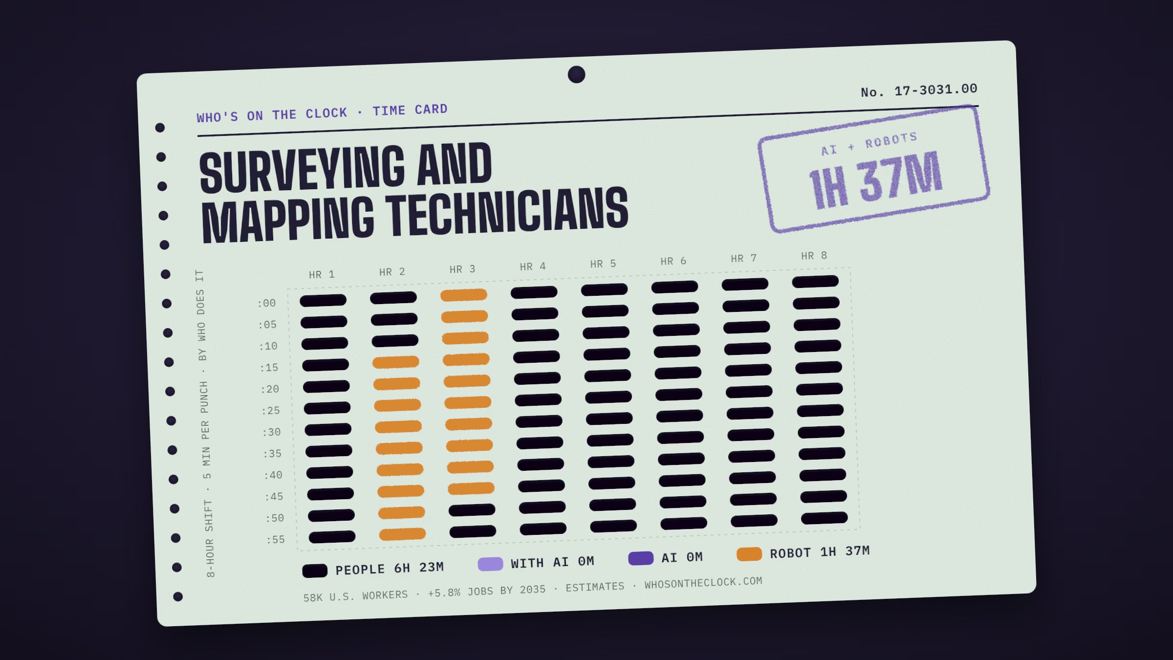
Perform surveying and mapping duties, usually under the direction of an engineer, surveyor, cartographer, or photogrammetrist, to obtain data used for construction, mapmaking, boundary location, mining, or other purposes. May calculate mapmaking information and create maps from source data, such as surveying notes, aerial photography, satellite data, or other maps to show topographical features, political boundaries, and other features. May verify accuracy and completeness of maps.
Time card
Untick tasks you don't do, or set your own times.
| Mine | Task, by time spent | Human | With AI | AI | Robot |
|---|---|---|---|---|---|
Adjust and operate surveying instruments such as prisms, theodolites, electronic distance measuring equipment, or electronic data collectors.1h 13m a shift · Robots only in factory cellsWhy this label?Robots have done this only in factory setups built around the machine, so it stays Human for surveying and mapping technicians. How labels work | |||||
Conduct surveys to ascertain the locations of natural features and man-made structures on the Earth's surface, underground, and underwater, using electronic distance-measuring equipment, such as GPS, and other surveying instruments.1h 1m a shift · Robots deployed · e.g. Boston Dynamics Spot + Trimble X7 ("Setanta")Why this label?Marked Robot because Boston Dynamics Spot + Trimble X7 ("Setanta") (in real use) has done this task in a real workplace. It shows a robot can do it somewhere, not that most surveying and mapping technicians work alongside one. How labels work | |||||
Position and hold the vertical rods, or targets, that theodolite operators use for sighting to measure angles, distances, and elevations.36m a shift · Robots deployed · e.g. Dusty Robotics FieldPrinter / FieldPrinter 2Why this label?Marked Robot because Dusty Robotics FieldPrinter / FieldPrinter 2 (in real use) has done this task in a real workplace. It shows a robot can do it somewhere, not that most surveying and mapping technicians work alongside one. How labels work | |||||
Set out and recover stakes, marks, or other monumentation.36m a shift · No AI or robot evidence foundWhy this label?This is physical work, and no robot has been shown doing it yet. How labels work | |||||
Record survey measurements or descriptive data, using notes, drawings, sketches, or inked tracings.24m a shift · No AI or robot evidence foundWhy this label?No AI use or robot deployment showed up for this task in our data. That isn't proof it's safe; it may just be rare in the data. How labels work | |||||
Search for section corners, property irons, or survey points.24m a shift · No AI or robot evidence foundWhy this label?This is physical work, and no robot has been shown doing it yet. How labels work | |||||
Compile information necessary to stake projects for construction, using engineering plans.18m a shift · No AI or robot evidence foundWhy this label?No AI use or robot deployment showed up for this task in our data. That isn't proof it's safe; it may just be rare in the data. How labels work | |||||
Collect information needed to carry out new surveys, using source maps, previous survey data, photographs, computer records, or other relevant information.18m a shift · No AI or robot evidence foundWhy this label?No AI use or robot deployment showed up for this task in our data. That isn't proof it's safe; it may just be rare in the data. How labels work | |||||
Enter Global Positioning System (GPS) data, legal deeds, field notes, or land survey reports into geographic information system (GIS) workstations so that information can be transformed into graphic land descriptions, such as maps and drawings.18m a shift · No AI or robot evidence foundWhy this label?No AI use or robot deployment showed up for this task in our data. That isn't proof it's safe; it may just be rare in the data. How labels work | |||||
Perform calculations to determine earth curvature corrections, atmospheric impacts on measurements, traverse closures or adjustments, azimuths, level runs, or placement of markers.18m a shift · No AI or robot evidence foundWhy this label?No AI use or robot deployment showed up for this task in our data. That isn't proof it's safe; it may just be rare in the data. How labels work | |||||
Prepare topographic or contour maps of land surveyed, including site features and other relevant information, such as charts, drawings, and survey notes.18m a shift · No AI or robot evidence foundWhy this label?No AI use or robot deployment showed up for this task in our data. That isn't proof it's safe; it may just be rare in the data. How labels work | |||||
Research and combine existing property information to describe property boundaries in relation to adjacent properties, taking into account parcel splits, combinations, or land boundary adjustments.12m a shift · No AI or robot evidence foundWhy this label?No AI use or robot deployment showed up for this task in our data. That isn't proof it's safe; it may just be rare in the data. How labels work | |||||
Calculate latitudes, longitudes, angles, areas, or other information for mapmaking, using survey field notes or reference tables.12m a shift · No AI or robot evidence foundWhy this label?No AI use or robot deployment showed up for this task in our data. That isn't proof it's safe; it may just be rare in the data. How labels work | |||||
Trace contours or topographic details to generate maps that denote specific land or property locations or geographic attributes.12m a shift · No AI or robot evidence foundWhy this label?No AI use or robot deployment showed up for this task in our data. That isn't proof it's safe; it may just be rare in the data. How labels work | |||||
Answer questions and provide information to the public or to staff members regarding assessment maps, surveys, boundaries, easements, property ownership, roads, zoning, or similar matters.12m a shift · No AI or robot evidence foundWhy this label?No AI use or robot deployment showed up for this task in our data. That isn't proof it's safe; it may just be rare in the data. How labels work | |||||
Supervise or coordinate activities of workers engaged in surveying, plotting data, drafting maps, or producing blueprints, photostats, or photographs.12m a shift · No AI or robot evidence foundWhy this label?No AI use or robot deployment showed up for this task in our data. That isn't proof it's safe; it may just be rare in the data. How labels work | |||||
Check all layers of maps to ensure accuracy, identifying and marking errors and making corrections.6m a shift · No AI or robot evidence foundWhy this label?No AI use or robot deployment showed up for this task in our data. That isn't proof it's safe; it may just be rare in the data. How labels work | |||||
Design or develop information databases that include geographic or topographic data.6m a shift · No AI or robot evidence foundWhy this label?No AI use or robot deployment showed up for this task in our data. That isn't proof it's safe; it may just be rare in the data. How labels work | |||||
Monitor mapping work or the updating of maps to ensure accuracy, inclusion of new or changed information, or compliance with rules and regulations.6m a shift · No AI or robot evidence foundWhy this label?No AI use or robot deployment showed up for this task in our data. That isn't proof it's safe; it may just be rare in the data. How labels work | |||||
Produce or update overlay maps to show information boundaries, water locations, or topographic features on various base maps or at different scales.6m a shift · No AI or robot evidence foundWhy this label?No AI use or robot deployment showed up for this task in our data. That isn't proof it's safe; it may just be rare in the data. How labels work | |||||
Determine scales, line sizes, or colors to be used for hard copies of computerized maps, using plotters.6m a shift · No AI or robot evidence foundWhy this label?No AI use or robot deployment showed up for this task in our data. That isn't proof it's safe; it may just be rare in the data. How labels work | |||||
Identify and compile database information to create requested maps.6m a shift · No AI or robot evidence foundWhy this label?No AI use or robot deployment showed up for this task in our data. That isn't proof it's safe; it may just be rare in the data. How labels work | |||||
Operate and manage land-information computer systems, performing tasks such as storing data, making inquiries, and producing plots and reports.6m a shift · No AI or robot evidence foundWhy this label?No AI use or robot deployment showed up for this task in our data. That isn't proof it's safe; it may just be rare in the data. How labels work | |||||
Compare survey computations with applicable standards to determine adequacy of data.6m a shift · No AI or robot evidence foundWhy this label?No AI use or robot deployment showed up for this task in our data. That isn't proof it's safe; it may just be rare in the data. How labels work | |||||
Compare topographical features or contour lines with images from aerial photographs, old maps, or other reference materials to verify the accuracy of their identification.6m a shift · No AI or robot evidence foundWhy this label?No AI use or robot deployment showed up for this task in our data. That isn't proof it's safe; it may just be rare in the data. How labels work | |||||
Provide assistance in the development of methods and procedures for conducting field surveys.6m a shift · No AI or robot evidence foundWhy this label?No AI use or robot deployment showed up for this task in our data. That isn't proof it's safe; it may just be rare in the data. How labels work | |||||
Complete detailed source and method notes describing the location of routine or complex land parcels.6m a shift · No AI or robot evidence foundWhy this label?No AI use or robot deployment showed up for this task in our data. That isn't proof it's safe; it may just be rare in the data. How labels work | |||||
Prepare cost estimates for mapping projects.6m a shift · No AI or robot evidence foundWhy this label?No AI use or robot deployment showed up for this task in our data. That isn't proof it's safe; it may just be rare in the data. How labels work | |||||
Analyze aerial photographs to detect and interpret significant military, industrial, resource, or topographical data.time not estimated · No AI or robot evidence foundWhy this label?No AI use or robot deployment showed up for this task in our data. That isn't proof it's safe; it may just be rare in the data. How labels work | |||||
Trim, align, and join prints to form photographic mosaics, maintaining scaled distances between reference points.time not estimated · Robots only in factory cellsWhy this label?Robots have done this only in factory setups built around the machine, so it stays Human for surveying and mapping technicians. How labels work |