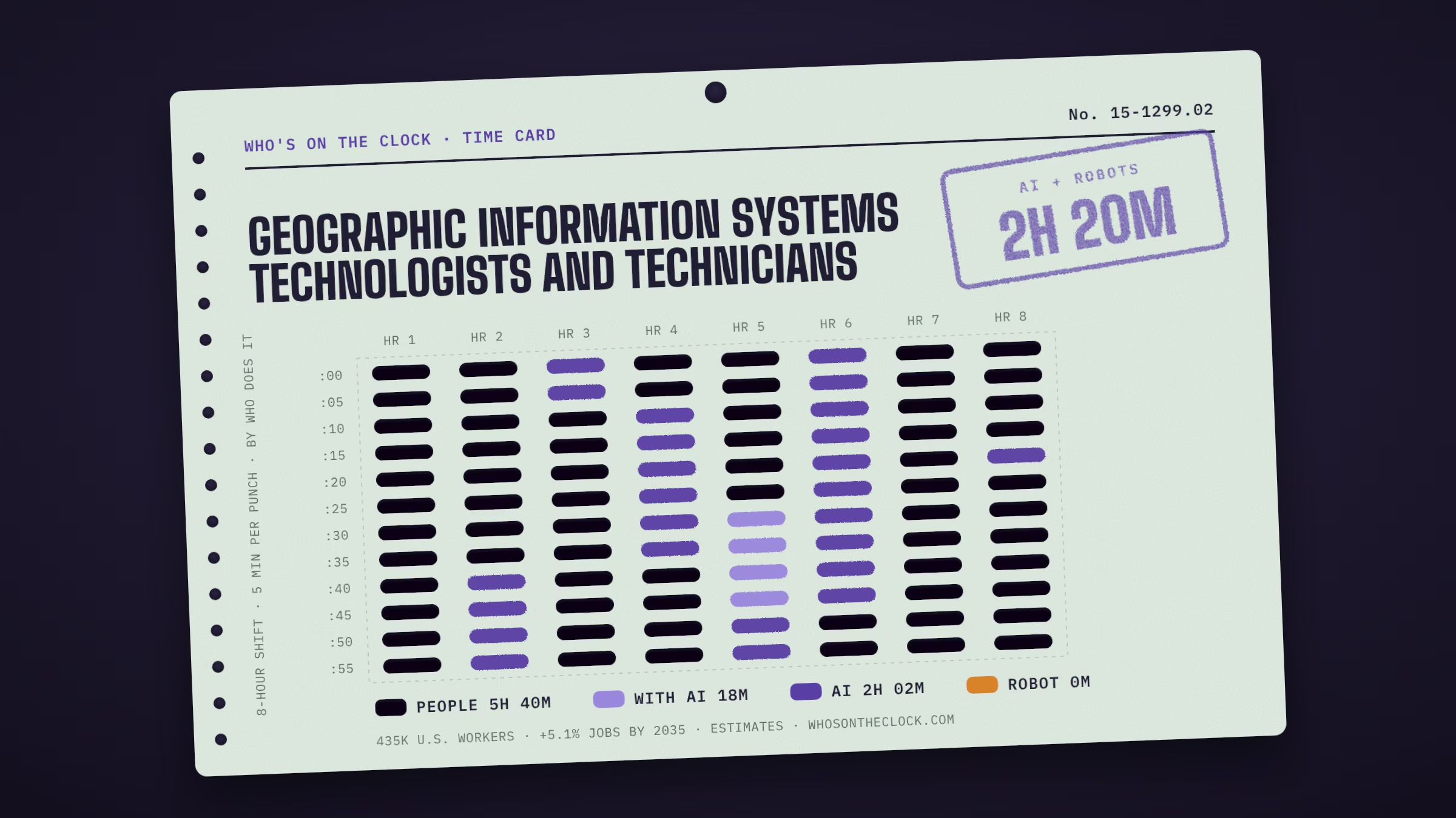
Assist scientists or related professionals in building, maintaining, modifying, or using geographic information systems (GIS) databases. May also perform some custom application development or provide user support.
Time card
Untick tasks you don't do, or set your own times.
| Mine | Task, by time spent | Human | With AI | AI | Robot |
|---|---|---|---|---|---|
Produce data layers, maps, tables, or reports, using spatial analysis procedures or Geographic Information Systems (GIS) technology, equipment, or systems.55m a shift · No AI or robot evidence foundWhy this label?No AI use or robot deployment showed up for this task in our data. That isn't proof it's safe; it may just be rare in the data. How labels work | |||||
Maintain or modify existing Geographic Information Systems (GIS) databases.43m a shift · No AI or robot evidence foundWhy this label?No AI use or robot deployment showed up for this task in our data. That isn't proof it's safe; it may just be rare in the data. How labels work | |||||
Perform computer programming, data analysis, or software development for Geographic Information Systems (GIS) applications, including the maintenance of existing systems or research and development for future enhancements.30m a shift · Observed in AI useTypical AI request: about 7h 43m alone, 1h 6m with AIWhy this label?Marked AI because this task shows up regularly in real AI conversations (Anthropic Economic Index, 2025 usage), and in most of them AI does the task on its own rather than helping a person. Many workplaces may not use AI for it at all. How labels work | |||||
Enter data into Geographic Information Systems (GIS) databases, using techniques such as coordinate geometry, keyboard entry of tabular data, manual digitizing of maps, scanning or automatic conversion to vectors, or conversion of other sources of digital data.30m a shift · No AI or robot evidence foundWhy this label?No AI use or robot deployment showed up for this task in our data. That isn't proof it's safe; it may just be rare in the data. How labels work | |||||
Review existing or incoming data for currency, accuracy, usefulness, quality, or completeness of documentation.30m a shift · No AI or robot evidence foundWhy this label?No AI use or robot deployment showed up for this task in our data. That isn't proof it's safe; it may just be rare in the data. How labels work | |||||
Perform geospatial data building, modeling, or analysis, using advanced spatial analysis, data manipulation, or cartography software.30m a shift · Observed in AI useWhy this label?Marked AI because this task shows up regularly in real AI conversations (Anthropic Economic Index, 2025 usage), and in most of them AI does the task on its own rather than helping a person. Many workplaces may not use AI for it at all. How labels work | |||||
Design or prepare graphic representations of Geographic Information Systems (GIS) data, using GIS hardware or software applications.24m a shift · No AI or robot evidence foundWhy this label?No AI use or robot deployment showed up for this task in our data. That isn't proof it's safe; it may just be rare in the data. How labels work | |||||
Collect, compile, or integrate Geographic Information Systems (GIS) data, such as remote sensing or cartographic data for inclusion in map manuscripts.24m a shift · No AI or robot evidence foundWhy this label?No AI use or robot deployment showed up for this task in our data. That isn't proof it's safe; it may just be rare in the data. How labels work | |||||
Provide technical expertise in Geographic Information Systems (GIS) technology to clients or users.18m a shift · Observed in AI useTypical AI request: about 2h 23m alone, 59m with AIWhy this label?Marked With AI because people regularly use AI to help with this task in real conversations (Anthropic Economic Index, 2025 usage), but AI doesn't usually finish it alone. How labels work | |||||
Provide technical support to users or clients regarding the maintenance, development, or operation of Geographic Information Systems (GIS) databases, equipment, or applications.18m a shift · Observed in AI useTypical AI request: about 2h 8m alone, 1h 3m with AIWhy this label?Marked AI because this task shows up regularly in real AI conversations (Anthropic Economic Index, 2025 usage), and in most of them AI does the task on its own rather than helping a person. Many workplaces may not use AI for it at all. How labels work | |||||
Document, design, code, or test Geographic Information Systems (GIS) models, internet mapping solutions, or other applications.18m a shift · Observed in AI useWhy this label?Marked AI because this task shows up regularly in real AI conversations (Anthropic Economic Index, 2025 usage), and in most of them AI does the task on its own rather than helping a person. Many workplaces may not use AI for it at all. How labels work | |||||
Create, analyze, report, convert, or transfer data, using specialized applications program software.18m a shift · Observed in AI useTypical AI request: about 6h 29m alone, 29m with AIWhy this label?Marked AI because this task shows up regularly in real AI conversations (Anthropic Economic Index, 2025 usage), and in most of them AI does the task on its own rather than helping a person. Many workplaces may not use AI for it at all. How labels work | |||||
Design or coordinate the development of integrated Geographic Information Systems (GIS) spatial or non-spatial databases.12m a shift · No AI or robot evidence foundWhy this label?No AI use or robot deployment showed up for this task in our data. That isn't proof it's safe; it may just be rare in the data. How labels work | |||||
Perform integrated or computerized Geographic Information Systems (GIS) analyses to address scientific problems.12m a shift · No AI or robot evidence foundWhy this label?No AI use or robot deployment showed up for this task in our data. That isn't proof it's safe; it may just be rare in the data. How labels work | |||||
Select cartographic elements needed for effective presentation of information.12m a shift · No AI or robot evidence foundWhy this label?No AI use or robot deployment showed up for this task in our data. That isn't proof it's safe; it may just be rare in the data. How labels work | |||||
Meet with clients to discuss topics such as technical specifications, customized solutions, or operational problems.12m a shift · No AI or robot evidence foundWhy this label?No AI use or robot deployment showed up for this task in our data. That isn't proof it's safe; it may just be rare in the data. How labels work | |||||
Design, program, or model Geographic Information Systems (GIS) applications or procedures.12m a shift · No AI or robot evidence foundWhy this label?No AI use or robot deployment showed up for this task in our data. That isn't proof it's safe; it may just be rare in the data. How labels work | |||||
Conduct research, data analysis, systems design, or support for software such as Geographic Information Systems (GIS) or Global Positioning Systems (GPS) mapping software.12m a shift · No AI or robot evidence foundWhy this label?No AI use or robot deployment showed up for this task in our data. That isn't proof it's safe; it may just be rare in the data. How labels work | |||||
Read current literature, talk with colleagues, continue education, or participate in professional organizations or conferences to keep abreast of developments in Geographic Information Systems (GIS) technology, equipment, or systems.12m a shift · No AI or robot evidence foundWhy this label?No AI use or robot deployment showed up for this task in our data. That isn't proof it's safe; it may just be rare in the data. How labels work | |||||
Interpret aerial or ortho photographs.6m a shift · No AI or robot evidence foundWhy this label?No AI use or robot deployment showed up for this task in our data. That isn't proof it's safe; it may just be rare in the data. How labels work | |||||
Confer with users to analyze, configure, or troubleshoot applications.6m a shift · Observed in AI useTypical AI request: about 4h 33m alone, 1h 21m with AIWhy this label?Marked AI because this task shows up regularly in real AI conversations (Anthropic Economic Index, 2025 usage), and in most of them AI does the task on its own rather than helping a person. Many workplaces may not use AI for it at all. How labels work | |||||
Develop specialized computer software routines, internet-based Geographic Information Systems (GIS) databases, or business applications to customize geographic information.6m a shift · No AI or robot evidence foundWhy this label?No AI use or robot deployment showed up for this task in our data. That isn't proof it's safe; it may just be rare in the data. How labels work | |||||
Make recommendations regarding upgrades, considering implications of new or revised Geographic Information Systems (GIS) software, equipment, or applications.6m a shift · No AI or robot evidence foundWhy this label?No AI use or robot deployment showed up for this task in our data. That isn't proof it's safe; it may just be rare in the data. How labels work | |||||
Assist users in formulating Geographic Information Systems (GIS) requirements or understanding the implications of alternatives.6m a shift · No AI or robot evidence foundWhy this label?No AI use or robot deployment showed up for this task in our data. That isn't proof it's safe; it may just be rare in the data. How labels work | |||||
Create visual representations of geospatial data, using complex procedures such as analytical modeling, three-dimensional renderings, or plot creation.6m a shift · No AI or robot evidence foundWhy this label?No AI use or robot deployment showed up for this task in our data. That isn't proof it's safe; it may just be rare in the data. How labels work | |||||
Prepare training materials for, or make presentations to, Geographic Information Systems (GIS) users.6m a shift · No AI or robot evidence foundWhy this label?No AI use or robot deployment showed up for this task in our data. That isn't proof it's safe; it may just be rare in the data. How labels work | |||||
Apply three-dimensional (3D) or four-dimensional (4D) technologies to geospatial data to allow for new or different analyses or applications.6m a shift · No AI or robot evidence foundWhy this label?No AI use or robot deployment showed up for this task in our data. That isn't proof it's safe; it may just be rare in the data. How labels work | |||||
Recommend procedures, equipment, or software upgrades to increase data accessibility or ease of use.6m a shift · No AI or robot evidence foundWhy this label?No AI use or robot deployment showed up for this task in our data. That isn't proof it's safe; it may just be rare in the data. How labels work | |||||
Transfer or rescale information from original photographs onto maps or other photographs.time not estimated · No AI or robot evidence foundWhy this label?No AI use or robot deployment showed up for this task in our data. That isn't proof it's safe; it may just be rare in the data. How labels work |